How to Draw a Site Plan in ArcSite
How to Draw a Site Plan in ArcSite
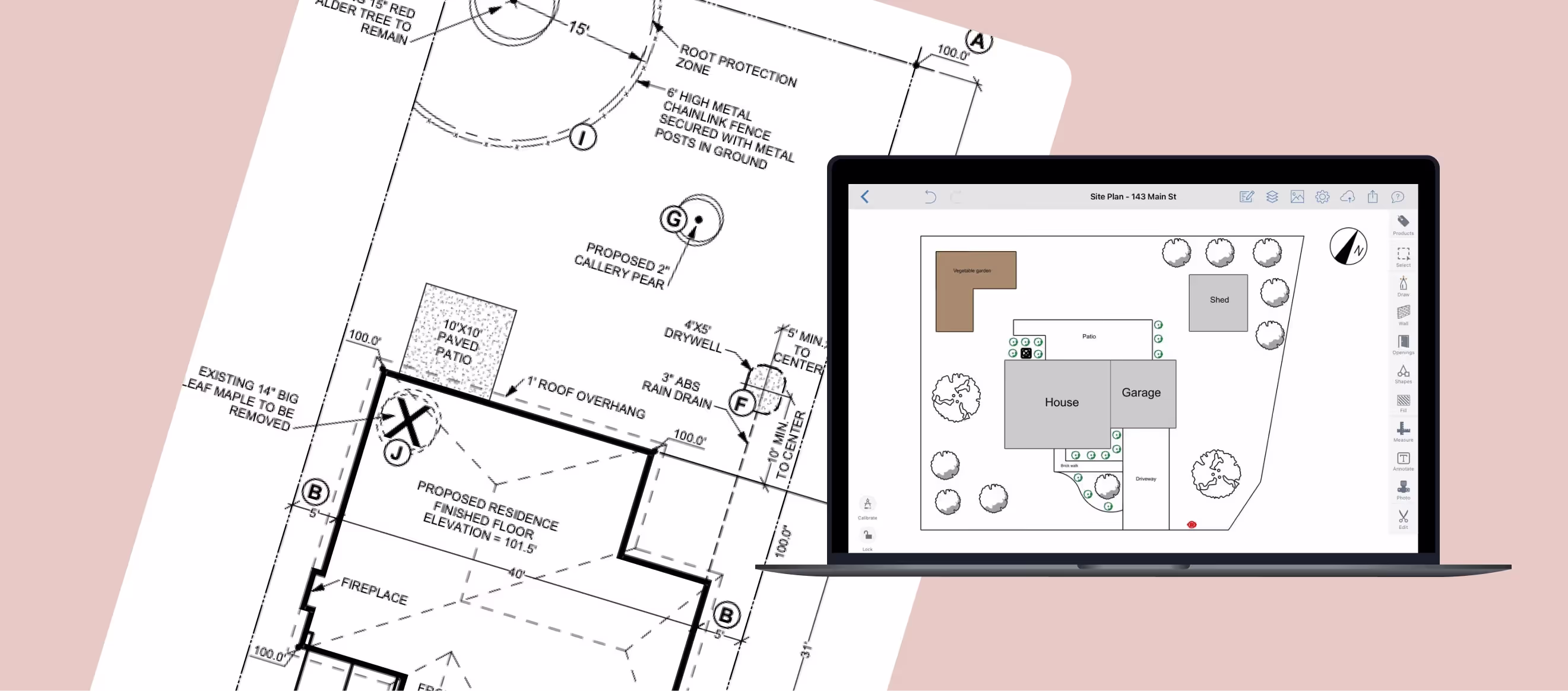
Creating a site plan is essential for construction, landscaping, and permitting processes. With ArcSite, you can generate precise site plans quickly, without the need for specialized design experience. Whether you're a contractor, architect, or property owner, this step-by-step guide will show you how to draw a site plan effortlessly using ArcSite's intuitive tools.
What is a Site Plan?
A site plan is a scaled drawing that represents property boundaries, structures, landscaping, utilities, and other features of a given site. It serves as a critical document for construction planning, obtaining permits, and communicating project details with clients and contractors.
To see more site plan examples, check out Site Plan Examples.
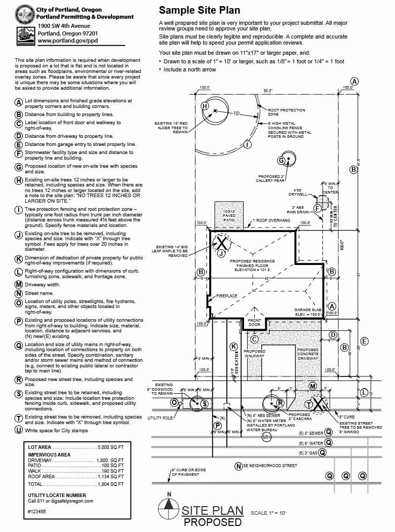
Site plans are used for permitting should follow guidelines for the city in which you're applying, so check with your local municipality for sample site plans and recommended features. Shown below is a great example from the city of Portland.
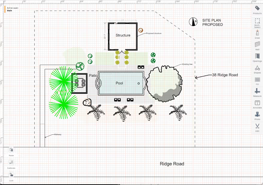
Steps to Create a Site Plan in ArcSite
What's ArcSite? In case you're not familiar with ArcSite, it's a mobile app that runs on tablets that allows you to walk around your site to easily draw site plans, instead of having to take measurements, then plug them into a complicated program on a laptop. We've create this step-by-step site plan guide based on ArcSite because it's readily available, isn't expensive, and is the easiest tool to learn. Alternative tools such as SketchUp or AutoCAD will requires weeks of training, so we prefer having you download ArcSite to get started right away.
Step 1: Set Your Drawing Scale
Before you start drawing, set your project's scale to match real-world measurements. A well-scaled site plan should include:
- Property boundary lines (to scale)
- Building footprints (house, garage, or additional structures)
- Driveways, walkways, and landscape features
- Utilities and drainage details (if applicable)
- Labels and dimensions for clarity


Step 2: Draw Basic Shapes
Using ArcSite’s 'Draw' tool, sketch the basic layout of your site. This includes property boundaries, buildings, and major structures. Choose between freehand drawing for quick sketches or precise line tools for accuracy. ArcSite allows easy movement, resizing, and rotation of drawn elements to fine-tune your design.

Step 3: Add Measurements
Click the 'Dimensions' tool to insert precise measurements directly onto your plan. Simply select two points, and ArcSite will automatically calculate and display the exact span between them. Proper dimensioning ensures your site plan meets local permitting requirements and contractor specifications.

Step 4: Insert Reusable Shapes
ArcSite provides an extensive shape library to enhance your plan with:
- Trees, shrubs, and landscape elements
- Utility markers for water, gas, or electrical lines
- Furniture and site fixtures
- Customizable symbols for project-specific needs
Simply drag and drop these elements into your site plan, or create your own custom symbols for added flexibility.

Step 5: Save and Share Your Site Plan
Before finalizing your drawing:
- Double-check all measurements for accuracy
- Ensure your plan meets local zoning and permit regulations
- Make any necessary adjustments
Once your site plan is complete, ArcSite offers multiple export options, allowing you to share it in PDF, DWG, or other common file formats. You can also send it directly to clients, team members, or local permitting offices with just a few taps.
Why Use ArcSite for Site Plans?
- User-Friendly Interface: No CAD experience needed—just tap, draw, and adjust.
- Works on Any Device: Create site plans on iOS, Android, or Windows devices.
- Professional-Level Precision: Ensure accurate measurements and details.
- Reusable Templates & Symbols: Save time by using pre-designed elements.
- Collaboration & Sharing: Share plans instantly with clients and teams.
For more information and a comprehensive look at site plans, check out Site Plans: Everything You Need to Know.
FAQs
What is a site plan used for?
A site plan is used in construction, landscaping, and city permitting. It provides a clear overview of property layouts, building placements, and essential site elements.
Can I use ArcSite to create a site plan on a mobile device?
Yes! ArcSite is available on iOS, Android, and Windows, making it easy to create site plans from a tablet or even a smartphone.
Is ArcSite suitable for beginners?
Absolutely. ArcSite's intuitive design tools allow users to create professional site plans without prior CAD experience.
Can I export my site plan from ArcSite?
Yes, you can export your site plan in PDF, DWG, or other standard file formats for easy sharing and submission.
Is ArcSite free to use?
ArcSite offers a free 14-day trial, allowing you to fully explore its features. After the trial, you can choose a subscription plan that best fits your needs.
Categories


Related posts


Try ArcSite for yourself
Not quite ready for a demo? Start a free 14-day trial of ArcSite with no credit card required!
Available on iOS, Android, and Windows devices.


